


Moore Twp. Voting District, Stevens County, Minnesota
About
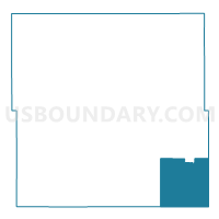
Outline

Summary
| Unique Area Identifier | 604587 |
| Name | Moore Twp. Voting District |
| County | Stevens County |
| State | Minnesota |
| Area (square miles) | 35.25 |
| Land Area (square miles) | 35.25 |
| Water Area (square miles) | 0.00 |
| % of Land Area | 100.00 |
| % of Water Area | 0.00 |
| Latitude of the Internal Point | 45.45492980 |
| Longtitude of the Internal Point | -95.80948870 |
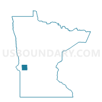
Maps

Graphs
Select a template below for downloading or customizing gragh for Moore Twp. Voting District, Stevens County, Minnesota


Neighbors
Neighoring Voting District (by Name) Neighboring Voting District on the Map
- Clontarf Twp. Voting District, Swift County, MN
- Darnen Twp. Voting District, Stevens County, MN
- Fairfield Twp. Voting District, Swift County, MN
- Hancock Voting District, Stevens County, MN
- Hodges Twp. Voting District, Stevens County, MN
- Hoff Twp. Voting District, Pope County, MN
- Horton Twp. Voting District, Stevens County, MN
- Tara Twp. Voting District, Swift County, MN
- Walden Twp. Voting District, Pope County, MN
Top 10 Neighboring County Subdivision (by Population) Neighboring County Subdivision on the Map
- Hancock city, Stevens County, MN (765)
- Darnen township, Stevens County, MN (292)
- Hodges township, Stevens County, MN (277)
- Moore township, Stevens County, MN (243)
- Horton township, Stevens County, MN (174)
- Walden township, Pope County, MN (169)
- Hoff township, Pope County, MN (152)
- Fairfield township, Swift County, MN (128)
- Tara township, Swift County, MN (88)
- Clontarf township, Swift County, MN (86)
Top 10 Neighboring Place (by Population) Neighboring Place on the Map
Top 10 Neighboring Unified School District (by Population) Neighboring Unified School District on the Map
- Morris Public School District, MN (7,092)
- Benson Public School District, MN (5,684)
- Hancock Public School District, MN (1,305)
Top 10 Neighboring State Legislative District Lower Chamber (by Population) Neighboring State Legislative District Lower Chamber on the Map
- State House District 13A, MN (38,763)
- State House District 11A, MN (37,492)
- State House District 20A, MN (32,187)
Top 10 Neighboring State Legislative District Upper Chamber (by Population) Neighboring State Legislative District Upper Chamber on the Map
- State Senate District 11, MN (76,648)
- State Senate District 13, MN (76,590)
- State Senate District 20, MN (66,816)
Top 10 Neighboring 111th Congressional District (by Population) Neighboring 111th Congressional District on the Map
Top 10 Neighboring Census Tract (by Population) Neighboring Census Tract on the Map
- Census Tract 4803, Stevens County, MN (3,306)
- Census Tract 9703, Pope County, MN (2,501)
- Census Tract 9603, Swift County, MN (1,805)